Toggle navigation
CDIP
About
About
Contact us
FAQ
Documents
News
Publications
Observations
Wave Models
California
N. California
San Francisco
Monterey Bay
Central Coast
S. California
Classic Models
More...
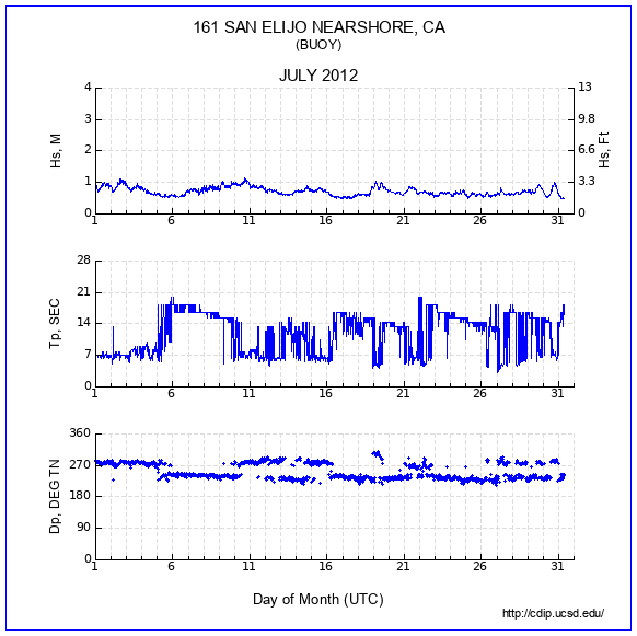
161 - SAN ELIJO NEARSHORE, CA
Status:
DECOMMISSIONED
Notice:
07/31/2012 Recovered buoy
Station Info
Data server
Historic data
Availability
Product descriptions
Waves
Single Run
9-band
Spectrum
Polar spectrum
Time series (xyz)
Wave histogram
Monthly
Parameter Data
Compendium
Mountain
Feather
9-band Energy Data
9-band Dir Data
Summaries
Waves 1 day
Waves 1 week
Wave hght box plot
Min Max Mean
Wave rose
Period rose
Landing conditions
Persistence
Joint distributions
Daily max wave
Sea and Swell
Largest events
Temperature
Monthly plot
Min Max Mean
Sea Temp summary
Download
Parameters
9-band Energy
9-band Direction
THREDDS
nDAR
Select a station
◄
2009-04
2009-05
2009-06
2009-07
2009-08
2009-09
2009-10
2009-11
2009-12
2010-01
2010-02
2010-03
2010-04
2010-05
2010-06
2010-07
2010-08
2010-09
2010-10
2010-11
2010-12
2011-01
2011-02
2011-03
2011-04
2011-05
2011-06
2011-07
2011-08
2011-09
2011-10
2011-11
2011-12
2012-01
2012-02
2012-03
2012-04
2012-05
2012-06
2012-07
Select a Station
No Overlay
028 SANTA MONICA BAY, CA
029 POINT REYES, CA
036 GRAYS HARBOR, WA
043 CAMP PENDLETON NEARSHORE, CA
045 OCEANSIDE OFFSHORE, CA
071 HARVEST, CA
076 DIABLO CANYON, CA
092 SAN PEDRO, CA
093 MISSION BAY OFFSHORE, CA
094 CAPE MENDOCINO, CA
096 DANA POINT, CA
098 MOKAPU POINT, HI
100 TORREY PINES OUTER, CA
106 WAIMEA BAY, HI
107 GOLETA POINT, CA
111 ANACAPA PASSAGE, CA
121 IPAN, GUAM
128 HUMBOLDT BAY SOUTH SPIT, CA
132 FERNANDINA BEACH, FL
134 FORT PIERCE, FL
139 UMPQUA OFFSHORE, OR
142 SAN FRANCISCO BAR, CA
143 CAPE CANAVERAL NEARSHORE, FL
144 ST. PETERSBURG OFFSHORE, FL
146 KAUMALAPAU, LANAI, HI
147 CAPE HENRY, VA
150 MASONBORO INLET, ILM2, NC
154 BLOCK ISLAND, RI
156 MONTEREY CANYON OUTER, CA
157 POINT SUR, CA
158 CABRILLO POINT NEARSHORE, CA
160 JEFFREYS LEDGE, NH
162 CLATSOP SPIT, OR
165 BARBERS POINT, HI
166 OCEAN STATION PAPA
167 SAN NICOLAS ISLAND NORTH, CA
168 HUMBOLDT BAY NORTH SPIT, CA
175 CENTRAL COOK INLET, AK
179 ASTORIA CANYON, OR
180 SAN FRANCISCO OFFSHORE, CA
181 RINCON, PUERTO RICO
182 SANTA CRUZ ISLAND SOUTH, CA
185 MONTEREY BAY WEST, CA
186 CAPE CHARLES, VA
187 PAUWELA, MAUI, HI
188 HILO, HAWAII, HI
190 NEW RIVER INLET, NC
191 POINT LOMA SOUTH, CA
192 OREGON INLET, NC
193 SAN PEDRO WEST, CA
195 LA PEROUSE BANK, CANADA
430 DUCK FRF 26M, NC
Viewing old data