Toggle navigation
CDIP
About
About
Contact us
FAQ
Documents
News
Publications
Observations
Wave Models
California
N. California
San Francisco
Monterey Bay
Central Coast
S. California
Classic Models
More...
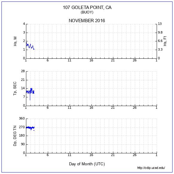
107 - GOLETA POINT, CA
Status:
DECOMMISSIONED
Notice:
11/03/2016 Station decommissioned
Station Info
Data server
Historic data
Availability
Product descriptions
Waves
Single Run
9-band
Spectrum
Polar spectrum
Time series (xyz)
Wave histogram
Monthly
Parameter Data
Compendium
Mountain
Feather
9-band Energy Data
9-band Dir Data
Summaries
Waves 1 day
Waves 1 week
Wave hght box plot
Min Max Mean
Wave rose
Period rose
Landing conditions
Persistence
Joint distributions
Daily max wave
Sea and Swell
Largest events
Temperature
Monthly plot
Min Max Mean
Sea Temp summary
Download
Parameters
9-band Energy
9-band Direction
THREDDS
nDAR
Select a station
◄
2002-06
2002-07
2002-08
2002-09
2002-10
2002-11
2002-12
2003-01
2003-02
2003-03
2003-04
2003-05
2003-06
2003-07
2003-08
2003-09
2003-10
2003-11
2003-12
2004-01
2004-02
2004-03
2004-04
2004-05
2004-06
2004-07
2004-08
2004-09
2004-10
2004-11
2004-12
2005-01
2005-02
2005-03
2005-04
2005-05
2005-06
2005-07
2005-08
2005-09
2005-10
2005-11
2005-12
2006-01
2006-02
2006-03
2006-04
2006-05
2006-06
2006-07
2006-08
2006-09
2006-10
2006-11
2006-12
2007-01
2007-02
2007-03
2007-04
2007-05
2007-06
2007-07
2007-08
2007-09
2007-10
2007-11
2007-12
2008-01
2008-02
2008-03
2008-04
2008-05
2008-06
2008-07
2008-08
2008-09
2008-10
2008-11
2008-12
2009-01
2009-02
2009-03
2009-04
2009-05
2009-06
2009-07
2009-08
2009-09
2009-10
2009-11
2009-12
2010-01
2010-02
2010-03
2010-04
2010-05
2010-06
2010-07
2010-08
2010-09
2010-10
2010-11
2010-12
2011-01
2011-02
2011-03
2011-04
2011-05
2011-06
2011-07
2011-08
2011-09
2011-10
2011-11
2011-12
2012-01
2012-02
2012-03
2012-04
2012-05
2012-06
2012-07
2012-08
2012-09
2012-10
2012-11
2012-12
2013-01
2013-02
2013-03
2013-04
2013-05
2013-06
2013-07
2013-08
2013-09
2013-10
2013-11
2013-12
2014-01
2014-02
2014-03
2014-04
2014-05
2014-06
2014-07
2014-08
2014-09
2014-10
2014-11
2014-12
2015-01
2015-02
2015-03
2015-04
2015-05
2015-06
2015-07
2015-08
2015-09
2015-10
2015-11
2015-12
2016-01
2016-02
2016-03
2016-04
2016-05
2016-06
2016-07
2016-08
2016-09
2016-10
2016-11
Select a Station
No Overlay
028 SANTA MONICA BAY, CA
029 POINT REYES, CA
036 GRAYS HARBOR, WA
043 CAMP PENDLETON NEARSHORE, CA
045 OCEANSIDE OFFSHORE, CA
067 SAN NICOLAS ISLAND, CA
071 HARVEST, CA
076 DIABLO CANYON, CA
092 SAN PEDRO, CA
094 CAPE MENDOCINO, CA
098 MOKAPU POINT, HI
100 TORREY PINES OUTER, CA
106 WAIMEA BAY, HI
111 ANACAPA PASSAGE, CA
121 IPAN, GUAM
132 FERNANDINA BEACH, FL
138 BEGG ROCK, CA
142 SAN FRANCISCO BAR, CA
143 CAPE CANAVERAL NEARSHORE, FL
146 KAUMALAPAU, LANAI, HI
147 CAPE HENRY, VA
150 MASONBORO INLET, ILM2, NC
154 BLOCK ISLAND, RI
157 POINT SUR, CA
158 CABRILLO POINT NEARSHORE, CA
160 JEFFREYS LEDGE, NH
162 CLATSOP SPIT, OR
163 KALO, MAJURO, MARSHALL ISLANDS
165 BARBERS POINT, HI
166 OCEAN STATION PAPA
168 HUMBOLDT BAY NORTH SPIT, CA
179 ASTORIA CANYON, OR
181 RINCON, PUERTO RICO
185 MONTEREY BAY WEST, CA
186 CAPE CHARLES, VA
187 PAUWELA, MAUI, HI
188 HILO, HAWAII, HI
189 AUNUU, AMERICAN SAMOA
191 POINT LOMA SOUTH, CA
192 OREGON INLET, NC
198 KANEOHE BAY, HI
200 WILMINGTON HARBOR, NC
201 SCRIPPS NEARSHORE, CA
202 HANALEI, KAUAI, HI
203 SANTA CRUZ BASIN, CA
204 LOWER COOK INLET, AK
205 BETTON ISLAND, KETCHIKAN, AK
209 BARNEGAT, NJ
210 OFFSHORE WIND ENERGY AREA, VA
213 SAN PEDRO SOUTH, CA
214 EGMONT CHANNEL ENTRANCE, FL
215 LONG BEACH CHANNEL, CA
216 HARVEST SOUTHEAST, CA
217 ONSLOW BAY OUTER, NC
220 MISSION BAY WEST, CA
221 CAPE COD BAY, MA
222 SANTA LUCIA ESCARPMENT, CA
224 WALLOPS ISLAND, VA
225 KANEOHE BAY, WETS, HI
226 PULLEY RIDGE, FL
430 DUCK FRF 26M, NC
Viewing old data